符合的藏品
共找到 186 筆符合的資料
An historical and geographical...
國立臺灣大學圖書館 格式:161面 格式:18.8公分 日期:[不詳] 資料類型:筆記 貢獻者:伊能嘉矩(著) An historical and geographical description.....more
- 1/186
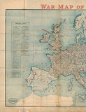
地圖名稱:War Map of Europe
資料識別碼:D-00-15-0062-11_s001 編繪者:Far Eastern Geographical Establishment 地圖 原件尺寸:63.0 * 82.2 (cm) 比例尺.....more
- 2/186
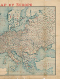
地圖名稱:War Map of Europe
資料識別碼:D-00-15-0062-11_s002 編繪者:Far Eastern Geographical Establishment 地圖 原件尺寸:63.0 * 82.2 (cm) 比例尺.....more
- 3/186
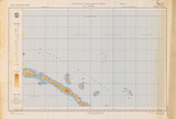
地圖名稱:SA-56 AUSTRALIAN GEOG...
圖 原件尺寸:86.1 * 58.4 (cm) 比例尺:1/1000000 地圖名稱:SA-56 AUSTRALIAN GEOGRAPHICAL SERIES 靜態圖像 數位化執行單位:中央研究院人文.....more
- 4/186

卷名:美國地理社團購書信函Purch...
團購書信函Purchase Order to American Geographical 數量:1 時間(起迄):1946/01/31~ 1946/01/31 型式:靜態圖像、文字 檔案層級:卷 出版.....more
- 5/186
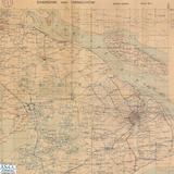
地圖名稱:SHANGHIA AND HANGCHOW...
版本:再版 出版日期:1942年9月 地區分類-大類:B01 中國大陸 資料識別碼:map_moi2_2moi00072 編繪者:Geographical Section General Staff.....more
- 6/186
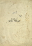
Cassells new atlas : a geograp...
, Georgeedited Publisher:Cassell and company, limited Cassell's new atlas : a geographical survey.....more
- 7/186

The Royal Atlas of Modern Geog...
of geographical discovery and research in the several countries, empires, and states of the world 日治時期臺灣研究.....more
- 8/186
地圖名稱:The REPUBLIC OF CHINA...
出版日期:1973年1月 地區分類-大類:B01 中國大陸 資料識別碼:map_moi2_7moi00079 編繪者:Chinese Geographical Inst 地圖 現存數量:9 色彩:全.....more
- 9/186
地圖名稱:The Republic of China...
出版日期:1962年1月 地區分類-大類:B01 中國大陸 資料識別碼:map_moi2_7moi00098 編繪者:Chinese Geographical,Institute 地圖 現存數量:5.....more
- 10/186

地圖名稱:TAIWAN
出版日期:1973年11月 地區分類-大類:A01 臺灣地區 資料識別碼:map_moi2_9moi00022 編繪者:Chinese Geographical Lnstitute 地圖 現存數量.....more
- 11/186

地圖名稱:TAIWAN
出版日期:1962年12月 地區分類-大類:A01 臺灣地區 資料識別碼:map_moi2_9moi00021 編繪者:Chinese Geographical Lnstitute 地圖 現存數量.....more
- 12/186
地圖名稱:香港九龍地區地形圖 HO...
出版日期:1936年 地區分類-大類:B01 中國大陸 地區分類-中類:B01031 香港特別行政區 資料識別碼:map_moi2_1moi00155 編繪者:英參謀本部,Geographical.....more
- 13/186
地圖名稱:Philips School-Room m...
GEOGRAPHICAL INSTITUTE 地圖 現存數量:1 色彩:全色圖 一郡一色 原件尺寸:120×180㎝ 比例尺:750000 出版地:英國 倫敦 備註:1. 民國76年3月27日建檔。 2. 本圖.....more
- 14/186

TRIPs Geographical Indications...
Geographical indications 地理標記 國家圖書館 19970100 期刊論文 賴文平 TRIPs "Geographical Indications"「地理標記」之研究 臺灣期.....more
- 15/186